On March 31, 2009, U S Leaseco, Inc, a Delaware corporation with a local address in Corvallis filed an application to change the Comprehensive Plan designation from Primary Agriculture to Public, seeking an exception to Statewide Planning Goals 3 (Agricultural Lands) and 14 (Urbanization) and for a conditional use for airport related uses on a 27.48 acre parcel located at 14497 Keil Rd and 22265 Airport Rd NE, Aurora, OR.
This is the same property for which the previous owners (Netter & Collett) submitted a zone change application in 2007 and withdrew it in July, 2008. In the past nine months U S Leaseco has acquired the Netter/Collett property and is seeking a zone change to construct a helicopter landing zone, 5 helicopter pads and a helicopter hangar on the property, allowing ‘through the fence’ access to the airport to enable a giant commercial helicopter operation and a massive increase in aviation traffic at Aurora Airport.
[Download a copy of the Land Use Request/Request For Comments (3/31/09)]
US Leaseco is a large helicopter charter service, operating 80 helicopters in the United States, Canada, and overseas. Their intent is to relocate their western US operations from Corvallis and consolidate them on this property adjacent to the Aurora Airport. This is made possible by “through the fence” airport access at the Aurora Airport (one of three Oregon airports eligible to participate).
The applicant intends to construct a 126,000 square foot hangar facility, including component and engine overhaul shop, inventory facility and management office space. The application requests a “reasons” exception” to Statewide Planning Goals 3 and 14, requesting an urban use on rural land, and from Primary Agriculture to Public, as well as the zoning from Exclusive Farm Use (EFU) to Public (P).
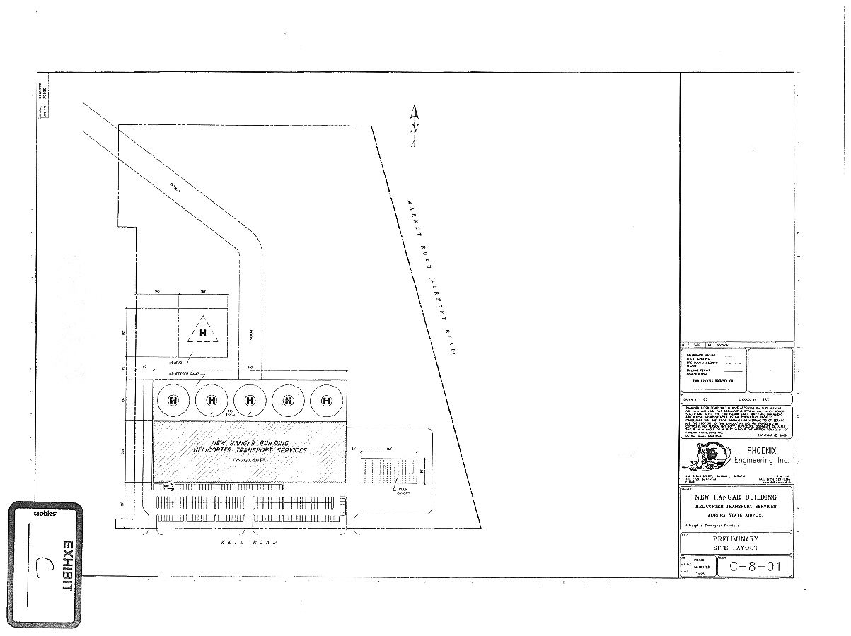
[Download engineering drawing of US Leaseco Hangar & Helipad drawing in PDF]
The application for the requested changes attempts to make the case that:
- There is a need for property to expand airport operations and the subject property is the most appropriate location for expansion.
- The economic benefits to be accrued to the immediate area by this facility with its projected 160 full time jobs (by the end of the 5th year of operation).
- An onsite well and septic system will be feasible to handle the required demands of the proposed use.
- No anticipated limitations exist to the air, water, energy and land resources.
Download the entire US Leaseco Application for zoning change in PDF.
Preserving Agricultural Lands First
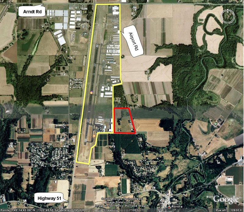
Subject property does abut the Aurora Airport at its southeast corner. It and the property directly north, as well as the property east of Airport Road and south of Keil Road are all zoned EFU. The property is adjacent to the airport and has an access road (Yellow Gate Lane) to the Airport, but none of that changes the fact that this is agricultural land, zoned EFU with Class 1 soils. The previous owners made the assertion in an earlier zoning attempt (which they withdrew in the face of opposition) that all of this property is comprised of low quality soils.
A look at the aerial map below quickly shows how misleading this assertion about poor quality land was. The airport is essentially surrounded by EFU agricultural land, with a few exceptions. Most of the land to the west across Highway 51 and all the land to the east across Airport Road is intensively farmed. The majority of the land to the south and southeast is zoned EFU and is being farmed.
What is wrong with this application?
There are two principal problems.
- The subject property is one of 17 pieces of property to the south and southeast of the airport. As pointed out, this is the only expansion direction available to the airport. The last piece of land to be integrated into the airport was not in agricultural usage and became the airport water and septic facility. This property, and the adjoining 16 pieces of property are all agricultural farm land with high quality soil. If one goes, the odds are very high on all the rest being “integrated” into the airport sooner or later. If the property owners want to sell their land, they should do so within the zoning and to people who plan on farming.
- The fact that the Aurora Airport sits in the middle of high quality farm land through a quirk of fate (the need for a second airport during World War II) does not minimize the value of the farm land. The economic interests and desires of the airport and the private commercial interest therein do not de-value the surrounding farm land. The purpose of Statewide Planning Goal 3 is to protect agricultural land.
Expansion pressures from Metro Portland in the past two decades have made the I-5 corridor south of the Willamette River among the most pressured to convert agricultural land for development. This area is the Gateway to the Willamette Valley-that is to say, the gateway from Metro Portland to the most fertile and productive lands in the state and the world. It has to be treated as such. All development in this area has to be considered with great care, and the value of the farm land has to be a major element in the assessment.
The starting point has to be that farmland should be preserved not developed. Climate change, rising fuel costs, contamination of imported commodities and other factors have all contributed to the understanding that we must “think global but buy local.” The fact is we may desperately need our farm land in a few years, and one certainty will always prevail: when farm land is taken out of agricultural usage and paved over, it never goes back.
FOFP’s Position on this application
FOFP is strongly opposed to this application and the conversion of any farmland for non-agricultural purpose where the change serves only a very small minority interest (those in the aviation industry) and does so at the long term expense of farming, farmers and our land.
Beyond the principle of converting Agricultural Land with Class 1 soils into urban uses, the other problems with the application include:
- The so-called “need” presented in the application for an expansion of airport related business is an expression of the Applicants business desires. No such “need” is defined in the 1976 Aurora Airport Master Plan or it’s October, 2000 update. Rather, this property is described therein only as “acceptable for airport-related development.”
- The economic benefit to be locally derived rides on the back of current infrastructure, and is premised on the assertions that very little additional traffic will be created, or other infrastructure service needs.
- Water usage by the industrial applications would likely strain existing water supplies, already problematic is this part of French Prairie; further the sewage waste created by 160 personnel are far beyond septic tank capacity in a small portion of this 27 acre property.
- The increase in helicopter flights will contribute substantial noise pollution to the surrounding area, especially to the residential areas south of subject property, as well as raise significant safety issues by adding a large quantity of helicopter traffic to the existing Aurora Airport traffic patterns without a control tower.
[Download Friends of French Prairie’s Letter of Opposition to this application in PDF]
What is missing in this discussion is an Area or Regional Master Plan for the northern end of the Willamette Valley. FOFP is calling on Marion County and the leaders of the municipalities involved to table all development and begin the process of formulating a long term Master Plan for the area bounded by the north Marion County line, Ehlen Road, the Pudding River and Butteville Road. Until such a plan is completed, with adequate public input from citizens and municipalities, only agriculture-related development consistent with the current zoning should be allowed to go forward.